11 Aeronautical information
Author’s note: This part goes through all the most commonly used data formats in the aviation and ATM data analysis community.
Airspaces & / or aeronautical information in general (AIRAC):
- airport information:
- ARP
- runway thresholds
- parking positions]
- Published Points
- Routes
- SID / STAR
- …
Aeronautical Information Management (AIM) is considered with the collection, assembly, publication, exchange, and dissemination of quality-assured, timely and digital aeronautical data in collaboration with all relevant stakeholders. Aeronautical data includes aeronautical information publications (AIP), notice to airmen (NOTAM), preflight information bulletins (PIB), and aeronautical information circulars (AIC).
Aeronautical Information Publications (AIP), which contain “aeronautical information of a lasting character essential to air navigation”, see [ICAO Annex 15][Annex_15], are issued by a state or by an authority of the state, such as an ANSP. Since their structure is standardized by ICAO Annex 15, AIP usually consist of three distinctive parts:
- GEN - General information: As the name implies, GEN contains general information, such as the authority responsible for the AIP, locally applied units of measure, abbreviations used in the AIP, locally applicable time zones and daylight saving time regulations, airspace charges regulations, etc.
- ENR - Information referring to en-route: ENR contains information that is of importance during the flight, i.e., while aircraft are en-route. ENR is divided into the following 6 parts: (i) information on general rules and procedures for Visual Flight Rules (VFR) and Instrument Flight Rules (IFR) or the airspace classes applied, (ii) description of the vertical and horizontal spread of airspaces, (iii) description of airways, (iv) description of radio navigation systems and infrastructures, (v) navigation warnings such as military airspaces, known aviation obstacles, danger areas, etc., and (vi) en-route chart material.
- AD - Information referring to aerodromes: AD includes information on both aerodromes and heliports and is divided into 3 parts. The first part contains an index of all aerodromes and helipads of a state as well as a description of the classification system of aerodromes applied in the state. Parts 2 and 3 of AD include detailed information on individual aerodromes or heliports, such as opening times, aerodrome operators, available service facilities, dimensions and alignment of runways, runway and approach lights, relevant aeronautical obstructions, etc. detailed maps are also provided, which contain information on ground-based infrastructure, i.e., aprons, taxiway, runways, etc., as well as flight procedures, i.e., standard instrument departures, standard terminal arrival routes, approach procedures.
To keep Aeronautical Information Publication (AIP)s up to date, they are revised in an internationally standardized cylce, which is known as the Aeronautical Information Regulation And Control (AIRAC) cycle. This AIRAC cycle follows a fixed 28-day rhythm, which is internationally standardised. The publication dates are known years in advance and are published, for example, by Eurocontrol.
Prefilght Information Bulletin (PIB) A PIB consists of a compilation of a number of Notice To Airmen (NOTAM)s which are important for the execution of a flight. Consequently, a PIB contains NOTAMs for the origin, destination and alternate airports, as well as NOTAMs for the airspace that the flight is likely to use.
Aeronautical Information Circular (AIC) [ICAO Annex 15][Annex_15] defines an AIC as “a notice containing information that does not qualify for the origination of a NOTAM of for inclusion in the AIP, but which relates to flight safety, air navigation, technical, administrative or legislative matters.” For example, AICs are issued to communicate a strategy in which a state explains how it aims to modernise its ground-based navigational aids, or how a certain new procedure will be implemented in the future.
Fatal events both en-route (mid-air collisions) and on the ground (landing or crashes) are at the origin of modern Air Traffic Control. In particular, flight plan filing was devised as a means to let controllers know where an aircraft was supposed to be and eventually be able to deconflict its trajectory with other flights nearby. The flight plan together with latest position reports was (and still is) the best information available to eventually launch search and rescue operations.
In principle, a flight plan could simply be a list of 4D coordinates (3D + time), but it surely was computationally and practically difficult to use it as such by ATC controllers who had to manually follow up airborne flights. So the en-route network was designed to have fixed and limited paths to follow. In doing so the probability of conflicts was increased but at the same time such network improves the efficiency in spotting them.
11.1 AIP
The data necessary for flight plan submission, air navigation and movements on the apron are managed via Aeronautical Information Publication (AIP) at country level by or on behalf of the respective civil aviation administration. The AIP structure and content is standardized. The AIP is normally composed of three parts
- GEN (general)
- ENR (en route)
- AD (aerodromes).
AIPs are kept up-to-date following a 28-day cycle known as the AIRAC (Aeronautical Information Regulation And Control) cycle, Figure 11.1. Revisions are produced every 56 days (double AIRAC cycle) or every 28 days (single AIRAC cycle). These changes are received well in advance so that users of the aeronautical data can update their systems, i.e. flight management systems (FMS) or ATC databases. AIPS are publicly available for example as listed at [1].
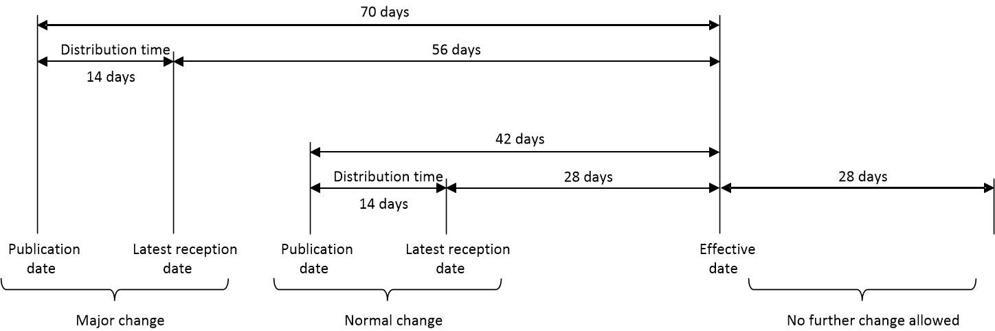
The schedule of internationally agreed AIRAC effective dates can be calculated as follows:
11.2 Airports, Points and Routes
On a macroscopic level an airport is represented by its location and code.
The location is called Airport Reference Point (ARP) and the rules governing its definition are established by section 2.2 of Annex 14 in [2]: it shall be located near the initial or planned geometric centre of the aerodrome and shall normally remain where first established.
Depending on its size and importance, an airport can have an ICAO and/or IATA code assigned, for example Amsterdam’s Schiphol has ICAO code EHAM and IATA code AMS.
- Check nomenclature, i.e. Significant Point, …
- References:
- ICAO Doc 4444
- Rules of the Air https://www.pilot18.com/wp-content/uploads/2017/10/Pilot18.com-ICAO-Annex-2-Rules-of-air.pdf
- https://skybrary.aero/articles/waypoint
- https://www.skybrary.aero/articles/ats-route
- EUROCONTROL HMI:
- NVA Navigation Aid
- PWP Published Way Point
- ICP Internal Point
- GEO GEO Point
- RFP Reference Point
- RAD RADAR Point
- TER Terminal Point
- BDY Boundary Point
- DME Distance Measuring Equipment
- VOR VHF Omni-directional radio Range
- VOR_DMEco-located VHF Omni-directional radio Range and Distance Measuring Equipment
- VOR_DME_NDB co-located VHF Omni-directional radio Range, Distance Measuring Equipment and Non-Directional Beacon
- VORTAC co-located VHF Omni-directional radio Range and TACtical Air Navigator
- DVOR Doppler VHF Omni-directional radio Range
- DVOR_DME co-located Doppler VHF Omni-directional radio Range and Distance Measuring Equipment
- DVOR_DME_NDBco-located Doppler VHF Omni-directional radio Range, Distance Measuring Equipment and Non-Directional Beacon)
- DVORTAC co-located Doppler VHF Omni-directional radio Range and TACtical Air Navigator
- ILS Instrument Landing System
- ILS_DME co-located Instrument Landing System and Distance Measuring Equipment
- ILS_LLZ co-located Instrument Landing System and Localizer
- ILS_LLZ_DME co-located Instrument Landing System, Localizer and Distance Measuring Equipment
- LLZ Localizer
- LLZ_DME co-located Localizer and Distance Measuring Equipment
- L Locator
- LI Inner Locator
- LM Middle Locator
- LO Outer Locator
- L_DME co-located Locator and Distance Measuring Equipment
- MLS Microwave Landing System
- NDB Non-Directional Beacon
- NDB_DME co-located Non-Directional Beacon and Distance Measuring Equipment
The aviation route network is characterized by the definition of geographical points, waypoints, and segments connecting them, route segments.
11.3 Airspaces
- different types of airspaces
- from EUROCONTROL CHMI:
- SECTOR ES Elementary Airspace Sector
- SECTOR CS Collapsed Sector
- AUA ATC Unit Airspace
- CLUSTER Airspace Cluster
- SECTOR CONFIGURATION Sector Configuration
- AUAGATC Unit Airspace Group
- REGION Region
- IR Information Region
- NAS National Airspace
- AREA Area
- ERSA Elementary Restricted Airspace
- CRSA Composed Restricted Airspace
- AOI Area of Interest
- AOP Area of Protection
- ERAS Elementary Regulated Airspace
- CRAS Composed Regulated Airspace
- AIRBLOCK Airblock
- from Skybrary: https://skybrary.aero/articles/classification-airspace
- from EUROCONTROL CHMI:
- AIC
- Aeronautical Information Circular
- AIM
- Aeronautical Information Management
- AIP
- Aeronautical Information Publication
- AIRAC
- Aeronautical Information Regulation And Control
- IFR
- Instrument Flight Rules
- NOTAM
- Notice To Airmen
- PIB
- Prefilght Information Bulletin
- VFR
- Visual Flight Rules