5 Air navigation services
Air navigation services represent the infrastructure that enables the safe, efficient, and orderly movement of aircraft through the world’s skies. Every commercial flight that takes off relies on a complex network of systems, services, and personnel working together to guide aircraft from departure gate to arrival gate. The foundation of this system rests on international agreements and legal frameworks that define responsibilities and standards. According to the Chicago Convention on International Civil Aviation of 1944, every state “has complete and exclusive sovereignty over the airspace above its territory”.
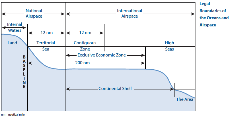
This sovereignty extends horizontally over the state’s entire territory, including territorial waters up to 12 nmi (22.2 km) from the coastline according to the United Nations Convention on the Law of the Sea. Vertically, a state’s airspace begins at the earth’s surface and extends to 100 km above mean sea level: the Kármán Line that legally separates the Earth’s atmosphere from space.
Under Article 28(a) of the Chicago Convention, each state must establish Air Navigation Service (ANS) within their airspace. To fulfill this obligation, states typically commission Air Navigation Service Provider (ANSP), i.e., public or private entities that deliver the essential services enabling aircraft operations.
TipANSPs in Europe
France’s air navigation services are provided by the Direction des Services de la Navigation Aérienne (DSNA), a government agency, while the United Kingdom’s services are delivered by National Air Traffic Services (NATS), a public-private partnership. In Germany, Deutsche Flugsicherung (DFS) operates as a state-owned enterprise.
5.2 Flight Information Regions
At the broadest level, global airspace is divided into Flight Information Regions (FIRs): large, internationally coordinated zones where designated authorities assume responsibility for delivering air traffic services. Within each FIR, the responsible authority provides flight information services and alerting services, including SAR, ensuring pilots receive essential information for safe and efficient operations while maintaining readiness to notify relevant organizations when aircraft require assistance.
FIRs are the primary organizational units of controlled airspace, covering both territorial and oceanic regions. While small countries may be covered by a single FIR, larger or busier nations often operate several. In some cases, FIRs span multiple countries or are assigned over international waters to nearby states. Their structures may vary with altitude: for example, France is divided into five FIRs below flight level (FL) 195, but merges into a single Upper Information Region (UIR) above that altitude. These regions, defined under the coordination of the International Civil Aviation Organization (ICAO), provide the foundation upon which more detailed subdivisions are built.
Warning
It is important to insist on the fact that FIRs are not expressions of territorial sovereignty, which is limited to 12 nautical miles from coastlines. FIRs represent commitments by states to provide air navigation services over much larger areas, including international airspace and oceanic regions.
Tip
More details about FIR around the world can be found on this page: https://observablehq.com/@openaviation/flight-information-regions
5.3 Air Traffic Services
Air Traffic Services (ATS) represent the core operational component of air traffic management, providing direct, real-time control and guidance of aircraft throughout all phases of flight. According to ICAO Annex 11, ATS encompasses four distinct but interconnected services that work together to ensure the safe, orderly, and expeditious flow of air traffic.
The four main services provided under ATS are:
- Air Traffic Control Service (ATC): The primary service responsible for preventing collisions between aircraft and between aircraft and obstacles on the maneuvering area, while optimizing air traffic operations for maximum efficiency
- Flight Information Service (FIS): Provides pilots with information useful for the safe and efficient conduct of flights
- Alerting Service (ALRS): Notifies appropriate organizations regarding aircraft in need of search and rescue aid
- Air Traffic Advisory Service: Provides advice and information to aircraft operating in advisory airspace where ATC service is not available
5.3.1 Flight rules
To ensure that airspace is managed efficiently and effectively by ATC, flights are categorized according to the flight rules they follow. Flights operate under either Visual Flight Rules (VFR) or Instrument Flight Rules (IFR).
Flights under Visual Flight Rules (VFR) follow the principle of “see and avoid”. Flight crews are responsible for maintaining visual separation from other aircraft and obstacles by looking outside the cockpit. VFR flights can only operate when meteorological conditions permit adequate visibility and cloud clearance. These conditions are referred to as Visual Meteorological Conditions (VMC).
Flights under Instrument Flight Rules (IFR) rely on both their instruments and air traffic control for navigation and separation. Flight crews are not required to maintain visual separation to other aircraft, as ATC provides separation services between IFR flights. IFR flights can operate in lower visibility conditions, known as Instrument Meteorological Conditions (IMC). With the exception of special VFR (SVFR)1 operations, when an aircraft conducts VFR flights although VMC are not met, flights must operate under IFR in IMC.
Besides differentiating between VFR and IFR flights, controlled airspace is classified into specific airspace classes that define which types of flight may use the airspace, under which circumstances flights may enter this airspace, and which services are offered to aircraft in this airspace.
The International Civil Aviation Organization (ICAO) defines in Annex 11 seven airspace classes, labeled A through G, with a fundamental distinction between Controlled Airspace (Classes A-E) where ATC provides services to aircraft, and Uncontrolled Airspace (Classes F-G) where no ATC services are provided.
Airspace classes differ in the type of flight allowed to enter and operate therein. While IFR flights are allowed to operate in all airspace classes, VFR flights are prohibited from using airspace Class A. Moreover, flights require an ATC clearance to enter certain airspace classes. If a clearance is required, pilots must contact ATC and request clearance before entering the airspace. As such, IFR and (if applicable) VFR flights require an ATC clearance for airspace Classes A, B, C, and D. In airspace Class E, only IFR aircraft require a clearance, while VFR flights are exempt from this obligation.
| Airspace Class | Flight Types Allowed | ATC Clearance Required |
|---|---|---|
| A | IFR only | Yes (IFR) |
| B | IFR and VFR | Yes (both) |
| C | IFR and VFR | Yes (both) |
| D | IFR and VFR | Yes (both) |
| E | IFR and VFR | Yes (IFR, SVFR), No (VFR) |
| F | IFR and VFR | No |
| G | IFR and VFR | No |
The airspace classes described above are established by the Chicago Convention on International Civil Aviation and are applicable to all states that have ratified this convention. However, this does not mean that every airspace class must be implemented by every state. Rather, each state has the flexibility to design its own airspace structure and determine which airspace classifications to apply within its sovereign territory.
For example, Italy uses airspace classes A, C, D, E, and G, while Germany, Austria, and Switzerland implement classes C, D, E, and G. In France, classes B and F are not utilized, and class A is restricted to the Paris region only. The French Upper Traffic Area, spanning from Flight Level (FL) 195 to FL 660, is designated as class C airspace: Air Traffic Control (ATC) provides comprehensive services to all aircraft, ensuring separation between IFR flights and between IFR and VFR flights. While VFR flights are not separated from each other by ATC, they do receive traffic information about other VFR operations to enhance situational awareness.
TipA practical illustration
VFR pilots need VFR aeronautical maps for flight planning to identify controlled airspace requiring ATC clearance, during flight for navigation and airspace awareness, and for training purposes. The following excerpt from an VFR aeronautical map shows controlled airspace around Toulouse, France.
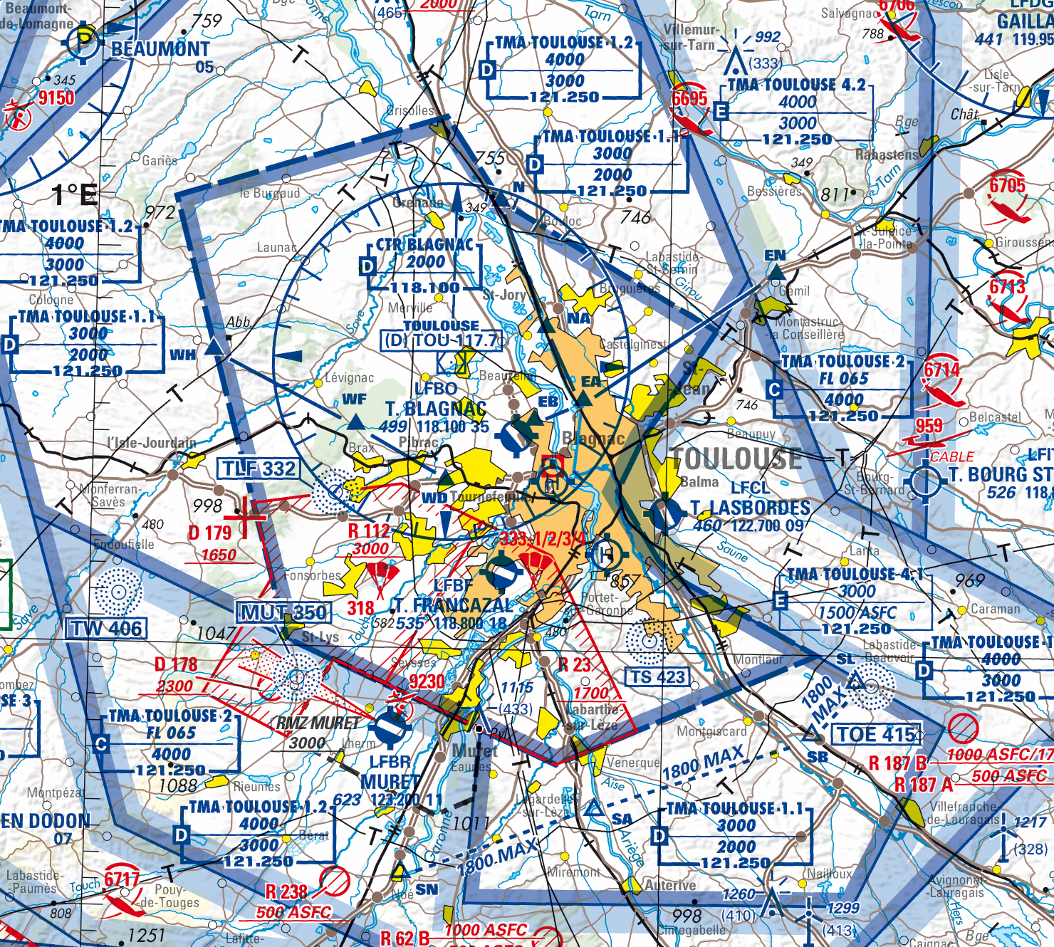
The major commercial airport is Toulouse-Blagnac, identified as LFBO. The Control Zone (CTR) extends from surface to 2,000 ft above mean sea level (AMSL) and is classified as class D airspace. The larger Terminal Manoeuvring Area (TMA) manages complex traffic flows with different airspace classes (C, D, and E) at various altitude levels.
VFR pilots operating from smaller airports, such as Toulouse-Lasbordes (LFCL) to the east of the city, use this map to identify altitude boundaries and airspace classifications. This information tells them where ATC clearances are required and what services are available. For example, pilots can see that from surface to 1,500 ft ASFC (above surface), they are operating below the TMA and do not interfere with Blagnac airport operations.
5.3.2 Air Traffic Control Service
Air Traffic Control (ATC) Service represents the most demanding and safety-critical component of air traffic services. Controllers work in specialized facilities using advanced surveillance systems (e.g., radar systems), communication equipment, and standardized procedures to maintain safe separation between aircraft while facilitating efficient traffic flow.
The fundamental principle of ATC is separation assurance, i.e., ensuring that aircraft maintain safe distances from each other at all times. Controllers achieve this through: tactical separation: real-time adjustments to aircraft paths, speeds, and altitudes to resolve conflicts; strategic separation: planned routing and timing to prevent conflicts from developing; or contingency management: immediate response to emergencies, equipment failures, or weather events.
ATC service is mandatory for all flights operating in controlled airspace, which includes airspace Classes A through E. The level of service provided varies depending on the airspace class and flight rules being followed.
| Airspace Class | Flight Rules | Separation provided |
|---|---|---|
| A | IFR only | Between all IFR flights |
| B | IFR, VFR | Between all flights |
| C | IFR | Between all flights |
| C | VFR | Between IFR and VFR flights |
| D | IFR | Between IFR flights |
| D | VFR | No separations (traffic information only) |
| E | IFR | Between IFR flights |
| E | VFR | No separations (traffic information only) |
| F | IFR, VFR | Between IFR flights, as far as practicable |
| G | IFR, VFR | No separations |
To prevent collisions between aircraft, ATC uses separation minima: specified minimum vertical and lateral distances that must be maintained between aircraft at all times. The specific separations provided depend on both the airspace class and the flight rules under which aircraft are operating.
Typical separation distances depend on the radar coverage and airspace type:
- En-route airspace: 10-20 nmi (long-range radar) or 5 nmi (European core area)
- Terminal airspace: 3 nmi near airports
- Precision radar areas: 2.5-2 nmi in airport proximity
In addition to lateral (horizontal) separation, controllers must also maintain vertical separation between aircraft. Standard vertical separation minima are:
- 1,000 feet between aircraft below FL290 (Flight Level 290, approximately 29,000 feet)
- 2,000 feet between aircraft at or above FL290 (reduced to 1,000 feet in RVSM airspace)
Reduced Vertical Separation Minima (RVSM) airspace allows 1,000 feet vertical separation between FL290 and FL410, increasing capacity and efficiency in busy airspace. Outside RVSM, the traditional 2,000 feet separation applies at these altitudes. For an aircraft to be permitted to enter and operate in RVSM airspace, its technical equipment must meet a number of requirements. Among other things, aircraft must be equipped with at least two independent altimeters, a secondary surveillance radar (SSR) transponder capable of reporting altitude, and an autopilot capable of maintaining the assigned flight level.
ATC operates 24/7 across three distinct operational environments, each requiring specialized training and procedures:
Aerodrome Control manages aircraft operations at airports, divided into two specialized functions. Tower Control coordinates takeoffs, landings, and aircraft movements in the immediate airport vicinity. Tower controllers work from airport control towers with panoramic views of runways, taxiways, and surrounding airspace. Ground Control specifically manages aircraft and vehicle movements on taxiways, aprons, and other ground areas of the airport. At busy airports, ground controllers work separately from tower controllers to handle the complex coordination required for aircraft pushback, taxi operations, and ground support vehicle movements.
Approach Control handles aircraft during the critical transition phases between aerodrome and en-route operations. These controllers manage departing aircraft as they climb to cruising altitude and arriving aircraft as they descend for landing. Approach control typically covers airspace from the airport surface up to approximately 10,000-15,000 feet within a 20-50 mile radius of major airports.
Area Control (En-route Control) manages aircraft during the cruise phase of flight, typically above 18,000 feet and across vast geographical areas. Area controllers work in area control centers, managing aircraft as they traverse airways and navigate between airports hundreds or thousands of miles apart.
Controllers usually work by pairs:
The executive controller, or tactical controller, is primarily responsible for managing aircraft within the boundaries of the sector. Their main task is to ensure safe separation between aircraft in real time, using radar surveillance and direct radio communication with pilots. They issue clearances such as heading changes, altitude adjustments, or speed restrictions, responding dynamically to evolving situations such as unexpected traffic convergence, weather deviations, or aircraft requests. The tactical controller is the voice pilots hear most often during flight.
The planner controller, or coordinator, is in constant communication with adjacent sectors, negotiating handovers and ensuring that aircraft are sequenced and spaced appropriately for entry into and exit from the controlled airspace. The planner controller anticipates potential conflicts before they enter the tactical window, helping to reduce workload for the executive controller and maintain an orderly flow of traffic. Depending on the specific traffic situation, these responsibilities can be handled by only one controller, who performs both the tasks assigned to the executive and planner controller. If needed, some tasks can also be delegated to a third controller, though this configuration is uncommon.
TipController responsibilities beyond separation
While separation assurance is the fundamental safety responsibility of air traffic controllers, their role extends far beyond maintaining safe distances between aircraft. Controllers actively optimize operations by sequencing traffic to maximize runway and airspace capacity. They provide tactical guidance such as speed adjustments, direct routings, and altitude optimizations to improve efficiency. Controllers also communicate critical information including weather updates, runway conditions, traffic advisories, and operational constraints. They coordinate with multiple stakeholders including pilots, other control positions, airline operations centers, and airport authorities. Finally, controllers manage contingencies such as weather deviations, equipment failures, medical emergencies, and irregular operations.
5.3.3 Flight Information Service
Flight Information Service represents a crucial informational component of air traffic services, providing pilots with essential data and advisories to support safe and efficient flight operations. Unlike ATC, which issues binding instructions and maintains separation responsibilities, FIS operates purely in an advisory capacity, disseminating information that pilots can use to make informed decisions about their flights.
FIS is universally available to all aircraft regardless of flight rules or airspace classification. Whether an aircraft operates under VFR or IFR, in controlled or uncontrolled airspace, pilots can access flight information services to enhance their situational awareness and operational safety.
The service covers several categories of information critical to flight operations:
Meteorological information. FIS provides pilots with current weather observations, forecasts, and significant weather phenomena along their route. This includes surface weather reports (METAR), terminal aerodrome forecasts (TAF), area forecasts covering broader geographical regions, and significant meteorological information (SIGMET) warnings about hazardous weather conditions such as severe turbulence, thunderstorms, or volcanic ash. Information about wind conditions, visibility, precipitation, cloud coverage, temperature, and barometric pressure settings helps pilots assess flight conditions and make routing decisions.
Airfield and navigation information keeps pilots informed about runway conditions, including surface contamination, construction activities, and temporary closures. The service also provides information about the runway in use, potential updates on wildlife hazards, particularly bird activity that may pose collision risks during takeoff and landing phases. The service also provides updates on the operational status of navigation aids, including VOR, DME, and ILS systems, alerting them to equipment outages that might affect their planned routes or approaches.
Traffic information services provide pilots with details about other aircraft operating in their vicinity when such information enhances safety awareness. Unlike ATC separation services, traffic information remains purely advisory and pilots retain full responsibility for maintaining their own separation from other aircraft and making appropriate collision avoidance decisions.
TipAerodrome Flight Information Service (AFIS)
At some smaller airports without full air traffic control services, Aerodrome Flight Information Service (AFIS) provides a specialized form of flight information service tailored to aerodrome operations. AFIS operators, working from airport control towers or dedicated facilities, provide pilots with essential information about aerodrome conditions, traffic movements, and local weather without issuing control instructions or clearances. AFIS typically operates at airports in uncontrolled airspace (Class F or G) where traffic volume justifies information services but not full air traffic control.
Operational information covers a broad range of data affecting flight operations, including temporary airspace restrictions, military exercise areas, parachuting activities, and other special use airspace activations. Pilots also receive information about airport operational changes, such as modified operating hours or temporary service limitations.
Emergency and safety information includes Notice To Airmens (NOTAMs) that deliver urgent operational updates, including obstacle alerts, airport construction impacts, or procedural modifications. FIS also distributes information regarding search and rescue activities, security-imposed airspace limitations, and other critical safety developments. A NOTAM provides information essential to flight operations personnel. Unlike Aeronautical Information Publications (AIPs) that contain relatively stable information with extended validity periods known well in advance, NOTAMs convey dynamic information that cannot be predicted sufficiently early for publication through other means. As defined by ICAO Annex 15, NOTAM is defined as “a notice distributed by means of telecommunication containing information concerning the establishment, condition or change in any aeronautical facility, service, procedure or hazard, the timely knowledge of which is essential to personnel concerned with flight operations.”
Modern FIS delivery increasingly incorporates digital systems alongside traditional voice communications. Automatic Terminal Information Service (ATIS) broadcasts provide standardized airport information on dedicated VHF frequencies, while digital data link systems can deliver weather and operational updates directly to aircraft systems. However, human operators remain essential for providing tailored information, interpreting complex situations, and responding to specific pilot requests.
5.3.4 Alerting Service
Alerting Service represents a critical safety net within air traffic services, designed to identify aircraft that may be in distress and initiate appropriate emergency response procedures. This service operates continuously, monitoring all flights within controlled airspace and maintaining vigilance for situations that might indicate an aircraft emergency.
The alerting service activates when specific conditions suggest an aircraft may require assistance. Overdue aircraft trigger alerts when they fail to arrive at their destination within a specified time after their estimated arrival, indicating potential navigation problems, fuel exhaustion, or other emergencies. Communication failures prompt alerting procedures when aircraft cannot establish or maintain required radio contact with air traffic control, suggesting equipment malfunctions or crew incapacitation. Emergency signals including distress calls, emergency transponder codes (such as 7700 for general emergency, 7600 for communication failure, or 7500 for hijacking/unlawful interference), or emergency locator transmitter activations immediately initiate alerting protocols.
The service employs a graduated response system with three escalating phases of emergency response. The Uncertainty Phase (INCERFA) activates when doubt exists about an aircraft’s safety, such as when an aircraft is overdue by 30 minutes or fails to report at a mandatory reporting point. The Alert Phase (ALERFA) begins when apprehension exists for aircraft and occupant safety, typically when an aircraft is significantly overdue or reports serious operational difficulties. The Distress Phase (DETRESFA) initiates when reasonable certainty exists that an aircraft and its occupants face grave and imminent danger, such as confirmed emergency landings or ditching procedures.
Upon activation, the alerting service coordinates with Search and Rescue Coordination Centers (RCC) and other appropriate organizations to mobilize rescue resources. This coordination includes military and civilian aviation assets, maritime rescue services, ground-based emergency teams, and international rescue organizations when aircraft cross national boundaries. The service maintains detailed flight plan information and aircraft tracking data to provide rescue teams with accurate last-known positions, aircraft specifications, fuel endurance, and passenger manifests.
5.3.5 Air Traffic Advisory Service
Air Traffic Advisory Service provides informational support to aircraft operating in designated advisory airspace where full air traffic control service is not available. This service fills a critical gap in areas where traffic density or infrastructure limitations make comprehensive ATC coverage impractical, yet aircraft still benefit from coordinated information sharing.
Advisory airspace typically covers remote regions, oceanic areas, or transitional zones between controlled airspace sectors. Unlike controlled airspace where ATC issues binding instructions and assumes separation responsibility, advisory airspace operates on an informational model where pilots retain full responsibility for navigation and collision avoidance while receiving valuable situational awareness data.
The service provides several categories of information to enhance flight safety. Traffic information alerts pilots to other known aircraft operating in the advisory area, including position reports, altitude information, and intended routes. Weather updates relevant to the advisory airspace help pilots make informed routing decisions and prepare for changing conditions. Navigational advisories may include information about the operational status of navigation aids or temporary restrictions affecting normal routing.
Controllers delivering advisory services coordinate with aircraft to collect and disseminate position reports, creating a shared operational picture that benefits all users of the airspace. When potential traffic conflicts are identified, controllers provide suggested routing or timing adjustments that pilots may choose to accept or modify based on their operational judgment.
Advisory service proves particularly valuable in oceanic and remote continental areas where radar coverage is limited or unavailable. In these regions, pilots rely heavily on procedural separation techniques and position reporting, making the information-sharing function of advisory service essential for maintaining situational awareness across vast distances.
The procedural nature of advisory service requires precise communication protocols and standardized reporting formats. Aircraft operating in advisory airspace typically follow established reporting points and time intervals, ensuring that traffic information remains current and actionable for all participants in the shared airspace.
5.4 Airspace Management
While ATS focuses on real-time control of aircraft, airspace management takes a strategic approach to optimizing airspace use. Airspace Management involves the strategic planning and real-time organization of airspace to optimize capacity and efficiency while maintaining safety. This includes:
- Airspace design: Structuring airways and sectors for optimal traffic flow and theoretical capacity
- Flexible airspace use: Dynamic allocation of airspace between civilian and military users
- Strategic capacity planning: Long-term analysis and planning for airspace modifications to increase capacity
- Coordination: Working with adjacent control centers and military authorities
5.4.1 Area Control Centres
Within each FIR or UIR, controlled airspace is further divided to ensure the safe and efficient management of air traffic across different phases of flight. Responsibility for these divisions typically lies with national or regional Air Traffic Control Centres, often referred to as Area Control Centres (ACCs), which oversee large volumes of airspace, often spanning thousands of square kilometres.
ACC areas of responsibility do not necessarily align with FIR or countries boundaries. ACCs are operational units that manage air traffic control services, while FIRs are administrative regions for air navigation services more broadly. This distinction becomes clear when examining real-world examples:
France operates five separate FIRs below FL 195 which consolidate into a single UIR above that altitude. However, air traffic control is managed by five main ACCs:
- Paris ACC (based in Athis-Mons near Paris) manages an extended approach sector for flights departing from or arriving at Paris airports;
- en route flows are managed by four regional ACCs: Brest ACC (North-West), Bordeaux ACC (South-West), Marseille/Aix ACC (South-East), and Reims ACC (North-East).
Two French ACCs extend their coverage beyond France’s UIR boundaries: Brest ACC extends into the Atlantic Ocean (covering portions of London and Shanwick FIRs), whilst Marseille ACC extends into Italy (covering part of Milano FIR). Conversely, some French airspace is managed by foreign ACCs: London ACC controls a small portion of Northern France, and Geneva ACC manages traffic above the Italian-French border on both sides of the Alps.
EUROCONTROL operates the Maastricht Upper Area Control Centre (MUAC), which manages en route traffic over the Benelux countries (comprising two FIRs) and a substantial portion of North-Western Germany. MUAC’s area of responsibility also extends slightly across the Belgian-French border. Low altitude traffic within these regions remains under the responsibility of the respective national providers: Belgocontrol (Belgium), LVNL (Netherlands), and DFS (Germany).
5.4.2 Elementary sectors
Because no single controller can monitor an entire centre, airspace is divided into small units called elementary sectors. Each sector is a defined volume of airspace with its own boundaries, typically based on geography, altitude, traffic volume, and operational needs. It is typically managed by a team of controllers who are responsible for all aircraft within that area. As an aircraft travels along its route, it will pass through multiple sectors. With each transition, responsibility for the flight is handed over from one team to the next. This hand-off process is standardized to ensure that aircraft are continuously monitored from take-off to landing.
Sector design considers multiple factors: geographical boundaries such as national borders, coastlines, or natural terrain features that provide logical divisions; traffic patterns including major airways, airport approach/departure corridors, and typical flight routes; altitude stratification with sectors often layered vertically to separate different flight levels; and operational complexity balancing workload distribution and coordination requirements between adjacent sectors.
In busy regions, sectors can be quite small and specialized, while in less busy areas, sectors may be much larger, with a single controller responsible for hundreds of square miles of airspace. Sectors are also layered vertically, meaning one controller might be responsible for aircraft flying between 24,000 and 32,000 feet, while another handles the same geographic area but at lower or higher altitudes.
5.4.3 Flight plans
Before any commercial flight takes off, a detailed flight plan must be created and filed. This plan outlines the intended route an aircraft will follow, including departure and arrival points, altitudes, estimated times, and the specific path through controlled airspace. Flight plans are essential for ensuring that air traffic controllers can manage the flow of aircraft safely and efficiently.
While predictable trajectories are essential, air traffic controllers can also offer direct routing when conditions allow2. If weather is clear and traffic conditions allow, controllers may instruct pilots to bypass certain waypoints or airways, offering a more efficient path that saves time and fuel. This flexibility is especially useful on longer flights, where even small adjustments can lead to significant operational savings.
Modern systems such as Performance-Based Navigation (PBN) and Required Navigation Performance (RNP) have further increased the precision and flexibility of routing, enabling aircraft to fly more direct paths even in complex or remote airspace.
Whether following a standard route or taking advantage of more direct navigation options, aircraft must still be carefully monitored to ensure their safety and controlled flow. This is the role of air traffic controllers. From guiding planes during takeoff to overseeing them en route and managing their approach for landing, controllers are essential to every phase of flight.
5.5 Air Traffic Flow Management
Air Traffic Flow Management (ATFM) focuses on optimizing traffic flows to prevent congestion and delays while maximizing the utilization of available airspace capacity. Traffic flow analysis involves monitoring and predicting traffic patterns to identify potential bottlenecks before they occur. When capacity is exceeded, flow control measures are implemented to manage traffic through restrictions such as ground delays or rerouting. Collaborative decision making ensures coordination with airlines and airports to minimize the impact of these measures on operations.
Dynamic capacity management represents a key operational component of ATFM, involving real-time adjustments to airspace configuration based on traffic demand and operational conditions. In high-traffic situations, sectors can be split into smaller units, each staffed by additional controllers to distribute workload and increase capacity. Conversely, during low-traffic periods, multiple small sectors may be combined into larger ones, optimizing controller utilization and reducing operational costs. This dynamic reconfiguration must also account for restricted zones, military operations areas, and weather events, all of which can require immediate adjustments to sector boundaries or traffic routing to maintain safety and efficiency.
5.5.1 Flight plans and routing
Before any commercial flight takes off, a detailed flight plan must be created and filed. This plan outlines the intended route an aircraft will follow, including departure and arrival points, altitudes, estimated times, and the specific path through controlled airspace. Flight plans are essential for ensuring that air traffic controllers can manage the flow of aircraft safely and efficiently.
To establish these routes, the aviation system relies on a network of predefined waypoints, which can be either specific geographic locations determined by GPS coordinates, or ground-based navigation aids such as VORs (VHF Omnidirectional Range beacons). These waypoints form the foundation of structured air traffic routes.
Traditionally, sequences of waypoints are connected to form airways, the highways of the sky. Aircraft follow these established corridors as part of their flight plans, allowing controllers to manage traffic safely and predictably, especially in busy or constrained airspace. Aircraft navigate from one waypoint to the next, following a path that resembles a series of connected legs rather than a single straight line. Modern aircraft are usually equipped with Flight Management System (FMS) that can store and follow these predefined routes automatically, making it easier for both pilots and controllers to maintain accurate navigation.
To further organise traffic in and out of airports, two types of standardized routes are used:
- Standard Instrument Departures (SID) guide aircraft from an airport’s runway to the en-route structure. These routes are designed to separate departures from each other and from arriving traffic.
- Standard Terminal Arrival Routes (STAR) lead aircraft from the en-route phase back into the terminal area for landing. Like SIDs, they help manage traffic flow and reduce controller workload.
These procedures are published on aviation charts and are often required for flights operating under Instrument Flight Rules (IFR), which govern most commercial and high-altitude air traffic.
While predictable trajectories are essential, air traffic controllers can also offer direct routing when conditions allow3. If weather is clear and traffic conditions allow, controllers may instruct pilots to bypass certain waypoints or airways, offering a more efficient path that saves time and fuel. This flexibility is especially useful on longer flights, where even small adjustments can lead to significant operational savings.
Modern systems such as PBN and RNP have further increased the precision and flexibility of routing, enabling aircraft to fly more direct paths even in complex or remote airspace.
Whether following a standard route or taking advantage of more direct navigation options, aircraft must still be carefully monitored to ensure their safety and controlled flow. This is the role of air traffic controllers. From guiding planes during takeoff to overseeing them en route and managing their approach for landing, controllers are essential to every phase of flight.
Glossary
- AFIS
- Aerodrome Flight Information Service
- AIM
- Aeronautical Information Management
- AIP
- Aeronautical Information Publication
- ANS
- Air Navigation Service
- ANSP
- Air Navigation Service Provider
- ATC
- Air Traffic Control
- ATFM
- Air Traffic Flow Management
- ATM
- Air Traffic Management
- ATS
- Air Traffic Services
- FMS
- Flight Management System
- IFR
- Instrument Flight Rules
- MET
- Meteorological Services
- NOTAM
- Notice To Airmen
- PBN
- Performance-Based Navigation
- RNP
- Required Navigation Performance
- SAR
- Search And Rescue
- VFR
- Visual Flight Rules
Special VFR (SVFR) flights are only allowed in controlled airspace, in which (i) the minimum visibility must be at least 1500m, (ii) ground must be visible at all times, and (iii) aircraft must be clear of clouds. Aircraft operating SVFR flights must be equipped as if they conducted an IFR flight.↩︎
https://wiki.ivao.aero/en/home/training/documentation/CTR_controller_position↩︎
https://wiki.ivao.aero/en/home/training/documentation/CTR_controller_position↩︎